
Create Voxels using 3D Gridding Methods
A "Voxel" is short for "volume pixel", the smallest distinguishable box-shaped element of a three-dimensional image. A Voxel is the 3D conceptual counterpart of the 2D pixel.
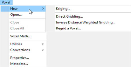
You can create a Voxel using the Voxel > New menu options located on the main toolbar in the current project or the Voxel > New Voxel menu options located on the main toolbar in the 3D Viewer.
The menu offers
-
The Kriging method best suits clustered data occurring in a region with otherwise sparse data distribution, such as geochemistry data.
-
The Direct Gridding method on the other hand should be used to grid data uniformly and densely sampled throughout the region, such as GPR or seismic data.
-
The Inverse Distance Weighted Gridding method is most suitable for gridding data collected along specific directions - such as borehole data.
The data to be gridded must have defined X, Y and Z coordinates. To define the coordinates, use the menu Coordinates > Set Current X,Y,Z Coordinates. The three- dimensional coordinate system will locate the data in 3D space. The Z axis is interpreted as positive up. The 3D workflow includes tools for creating, displaying and processing voxels.
The 3D Viewer enables visual inspection of voxels and comes with an extensive set of 3D viewing tools.
When applying 3D gridding, if you reduce the cell size by half, both the file size and processing time are increased by a factor of 8 (2 3).
Got a question? Visit the Seequent forums or Seequent support
© 2023 Seequent, The Bentley Subsurface Company
Privacy | Terms of Use